PROJECT OBJECTIVES
The objective of the Geo Referencing project was to create a visual comparison of aerial images from early as 1930 to the most recent image available. It entailed using Geographical Information Systems (GIS) software, specifically ArcGIS (ArcMap) and was used to complete a part in the Rare Species Project.
The objective of the Geo Referencing project was to create a visual comparison of aerial images from early as 1930 to the most recent image available. It entailed using Geographical Information Systems (GIS) software, specifically ArcGIS (ArcMap) and was used to complete a part in the Rare Species Project.
THEORETICAL BACKGROUND AND PROJECT RATIONALE
Geo Referencing is the process of associating a physical map or raster image of a map with spatial locations. This 10-minute YouTube video - https://www.youtube.com/watch?v=PHtxbpboDro - explains georeferencing in more detail. The benefits of having georeferenced maps are that you can easily compare and perform research on them through overlays.
For this project, spatially georeferenced maps from 1930 and the present were accessible, but the 1950 aerial maps needed to be georeferenced to effectively compare them to the rest. The interns were tasked to take points from the 1950 images and plot them to the actual, identical points located on site maps that were available to them. This task helps in keeping all three aerial versions of a site consistent in location. The skills required for georeferencing include being able to use spatial data, read tables in ArcMap and have knowledge around computers.
DELIVERABLES
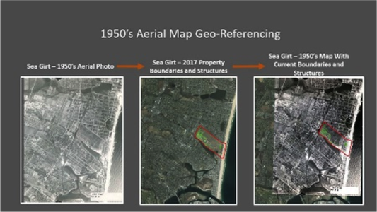
Using the ArcMap Georeferencing tool, the interns were able to match up key geological features from different time periods to successfully georeference the 1950 images. By doing this, one can view and analyze facility habitats over the years and gain a better understanding of the changes in habitat and the associated behavior of the species that inhabit the area.
The figures below are examples of GIS work that the interns created based from the aerial map georeferencing:
The figures below are examples of GIS work that the interns created based from the aerial map georeferencing:
BENEFITS TO SUEIP INTERNS
Through this project, interns were able to:
Through this project, interns were able to:
- Learn new applications of ArcMap i.e. Geo Referencing, etc.
- Visually assess the changes in habitat over the last 70 years
